|
Bay of Plenty Regional Navigation Safety Bylaws Review Committee Informal Workshop Pack
DATE: Tuesday 14 March 2023 COMMENCING AT TIME: 2.00 pm VENUE: Council Chambers, Regional House, 1 Elizabeth Street, Tauranga |
|
Bay of Plenty Regional Navigation Safety Bylaws Review Committee Informal Workshop Pack
DATE: Tuesday 14 March 2023 COMMENCING AT TIME: 2.00 pm VENUE: Council Chambers, Regional House, 1 Elizabeth Street, Tauranga |
Informal Workshop Papers
1 Verbal Update from previous Committee meeting
Presented by: Toni Briggs - Senior Project Manager
2 Kaituna River Speed Uplifting - Indicative Issues and Options 1
3 Hunters Creek Ski Area - Tauranga Harbour - Indicative Issues and Options 1
Attachment 1 - Hunters Creek 1
|
|
|
|
|
Informal Workshop Paper |
||
|
To: |
Bay of Plenty Regional Navigation Safety Bylaws Review Committee Workshop |
|
|
|
14 March 2023 |
|
|
From: |
Toni Briggs, Senior Project Manager |
|
|
|
Reuben Fraser, General Manager, Regulatory Services |
|
Kaituna River Speed Uplifting - Indicative Issues and Options
1. Purpose
The purpose of this paper is to outline the background, issues, and possible solutions to the long-debated presence of a speed uplifting on the Kaituna River.
2. Guidance Sought from Councillors
Before undertaking more focussed engagement with stakeholders and, the drafting of a new Bylaws document for consultation, staff seek guidance from the Committee on the following matters:
· Level of comfort in understanding the history and the on-going issues associated with the speed uplifting on the Kaituna River
· Level of comfort with the indicative options available (given we have yet to speak to the stakeholders about this review).
The possible options provided in this paper will be workshopped at the meeting to provide Committee member understanding on the rationale for proposing the options for possible solutions.
3. Discussion
3.1 Background
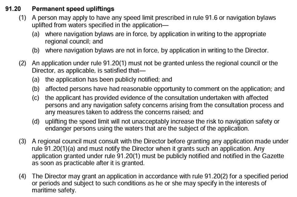
The New Zealand Maritime Rules, Part 91: Navigation Safety Rules state a vessel may not exceed 5 knots within 200 metres of the shore or a structure.
The Navigation Safety Bylaws are able to modify the 5 knot rule to increase the speed limit. The Bylaws must identify the area to which the increased speed applies and any conditions that may apply. This is called ‘speed uplifting’.
These Rules also allow for permanent speed upliftings where the Council “…. is satisfied that the uplifting of speed will not unacceptably increase the risk to navigation safety or endanger persons using the waters that are subject [to the speed uplifting]”.
Speed uplifting needs to thoroughly investigated to ensure there are no unintended consequences around safety if a higher speed is allowable.
The speed uplifting on the Kaituna River needs to be reviewed as there are an increasing number of competing uses on the river.
Maritime Rules Part 91 – Navigation Safety Rules enables Bylaws to make permanent speed upliftings if Council is satisfied that the uplifting will not unacceptably increase the risk of navigation safety or endanger persons using the water that are subject to the uplifting.
In the 2017 Bylaws review this was a contentious issue with many submissions. The commissioners recommended no change to the speed uplifting based on the evidence and submissions presented. The Commissioners also recommended:
· More consistent signage is used in carparks with Maritime Rules and that these are regularly checked and maintained
· Passive recreation areas and/or swimming areas are identified and looked at for the next Bylaw Review.
3.3 Bylaws History
 |
The Kaituna River, along with the Rangitāiki, Whakatāne, Tarawera, Waioeka, Mōtū and the Wairoa Rivers, were all subject to a speed uplifting within Gazette Notice P1546 17/5/79 (17 May 1979). This original speed uplifting applied to all waters of the Kaituna River, from the source to the sea. Since this Gazette Notice, speed upliftings in these rivers have been continuously in force with only minor modifications, with the exception of the Wairoa River, which is no longer subject to a speed uplifting.
In subsequent reviews, members of the community, including several submissions from Tapuika, submitted on removing the speed uplifting on Kaituna River due to river user safety issues.
A range of cultural practices, sacred sites and recreational swimming were identified by iwi in several submissions.
The 2010 Navigation Safety Bylaw effectively superseded the 1979 Gazette Notice and reduced the area that the speed uplifting applied to all navigable waters of the Kaituna River, upstream of the Bell Road boat ramp to the Mangorewa Confluence (immediately downstream of the commercial jet boating base).
In 2014, Council notified and had hearings to uplift the speed limit on the Kaituna River from the Mangorewa Confluence, to a point at the first rapids 12.5 km upstream.
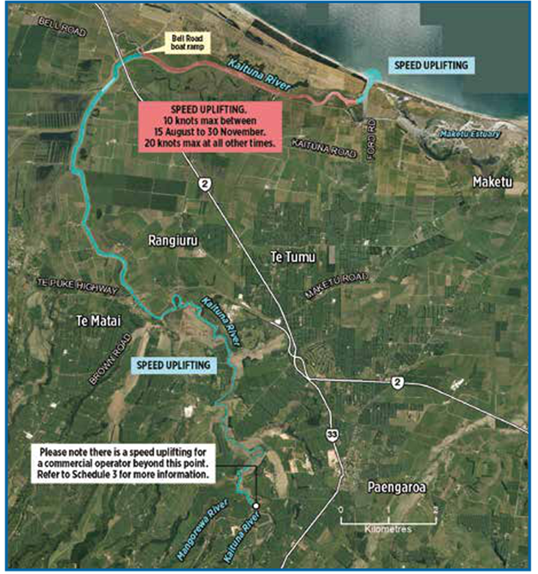
Currently (2017 Bylaw) there are four separate speed areas on the Kaituna River:
1. The Lower Kaituna River from Fords Cut, upstream to the Bell Road boat ramp. This speed uplifting is a variable speed limit, with a maximum of 20 knots, reducing to 10 knots during the whitebaiting season from 15 August to 30 November. The speed uplifting is available to all vessels.
2. The Lower Mid-Section of the Kaituna River from Bells Boat Ramp upstream to the Mangorewa Confluence. This area has no maximum speed and is available to all vessels.
3. The Upper Mid-Section of the Kaituna River from the Mangorewa Confluence to the first rapids 12.5km upstream. This area has no maximum speed limit but is subject to conditions that restrict the speed uplifting to commercial jet boating operations that have resource consent from the Western Bay of Plenty District Council.
4. The Upper Section of the Kaituna River upstream of the first rapids to the source is not subject to a speed uplifting, and as such, all vessels would have to maintain a speed of less than 5 knots. It should be noted that this section of the river is generally only utilised by kayakers and rafters.
3.4 Issues
Issue 1: Perception that jet boat wakes cause bank erosion. See Other Considerations below.
Issue 2: Safety of swimmers when jetboats travel at speed.
Issue 3: Increase in wider range of craft using the river (e.g. jetskis) and a wider range of passive activities (e.g. swimming, cultural practices, fishing, whitebaiting etc).
3.5 Other Considerations
2017 Bylaws Review Commissioners Recommendations
The following is an excerpt from the Independent Commissioners’ Report outlining their recommendations for the review of the speed uplifting in the previous Navigation Safety Bylaws 2017.
1.7 Our recommended decisions for Kaituna Speed Uplift:
No change to the speed upliftings as notified.
1. That there be no change to the proposed wording of the Bylaw with respect to the Speed Uplifting on the Kaituna River; and
2. That stakeholders utilise the provisions of Clause 3.9 (Special Events) to ensure there is an appropriate navigation safety environment for that event; and
3. Records are kept of activities and events on the Kaituna River to inform future reviews of the Navigation Safety Bylaw.
The Commissioners also recommended
That a Strategic Communications Plan is set up. This could include interested parties such as consent holders, river users, iwi, JBNZ, landowners and the local community. This plan would cover communication, clarification and education of boating rules, cultural events and the like. (initial Comms undertaken after adoption for 2017 Bylaws).
More consistent signage is used at car parks regarding maritime rules and that these are regularly checked and maintained. (Actioned 2017)
Passive recreation areas and or swimming areas are identified and looked at for the next Bylaw review. (Not actioned).
3.5.1 Iwi Management Plans
· Tapuika Environmental Management Plan
3.1.5 POLICIES FOR WATER - NGĀ KAUPAPA
6. Action Plan
Also Referenced, with no specific commentary on jetboating on the river, however objectives and actions will be considered in the review.:
· Ngāti Rangiwewehi Iwi Environmental Management Plan
· Te Rūnanga O Ngāti Pikiao Iwi Resource Management Strategy Plan
· Taheke 8C Draft Plan Change 5: Further Submission
3.5.2 Previous Erosion Reports
Erosion is perceived as a destructive side effect of jet boating, at speed, up the Kaituna River. Bay of Plenty Regional Council has commissioned three independent reports on the effects of jet boating on the banks of the Kaituna River and has undertaken in-house investigations to determine that validity of this. Unfortunately, none of the reports agree on the exact mechanisms causing bank erosion of the Kaituna River.
The most recent reports are as follows. Staff intend to undertake a desk-top review of the recommendations and outcomes for the combined reports.
o Review of jet boating effects on bank erosion in the Kaituna River New Zealand. Environmental Management Associates. April 2015.
o Investigation into the role of jet boating on bank erosion in the Kaituna River. NIWA. February 2012.
o Jet boat wakes on the Kaituna River: A report on erosion effects. School of Geography and Environmental Science University of Auckland University. April 2002
o Investigation of erosion in the Upper Kaituna River. Technical Memorandum Bay of Plenty Regional Council. Crabbe BK, Titchmarsh R. 1993.
3.6 Options
Staff have put together the following table of possible options for discussion at this workshop to support discussion:
|
Option |
Synopsis |
|
1: Status Quo (Current Situation) |
Keep the speed uplifting in schedule 3 as: "Areas subject to speed uplifting: All navigable waters of the Kaituna River upstream of the Bell Rd boat ramp to Mangorewa confluence" |
|
2: Remove Speed Uplifting from entire River |
Apply the 5 knot rule to the entire River. |
|
3: Remove Speed Uplifting on Lower river (from mouth to Mangorewa River confluence) |
|
|
4: Application of Passive recreation areas or swimming areas identified and designated as reserved for swimmer (i.e. vessel speed must be 5 knots) |
This was suggested by the Independent Commissioners of the 2017 Bylaws Hearings. |
The workshop will work through each option and discuss the pros, cons, risks, potential costs, and impacts.
An important consideration, as mentioned above, is that we have yet to discuss possible solutions with the affected communities.
Today staff will explain the tentative options, provide the rationale and context for each and work through possible solutions with the committee.
4. Next Steps
The next step is to engage directly with the key stakeholders on the options.
It will be important to ask stakeholders what they think solutions might be.
|
|
|
|
|
Informal Workshop Paper |
||
|
To: |
Bay of Plenty Regional Navigation Safety Bylaws Review Committee Workshop |
|
|
|
14 March 2023 |
|
|
From: |
Toni Briggs, Senior Project Manager |
|
|
|
Reuben Fraser, General Manager, Regulatory Services |
|
Hunters Creek Ski Area - Tauranga Harbour - Indicative Issues and Options
1. Purpose
The purpose of this paper is to outline the background, issues, and possible solutions to the long-debated presence of the Ski Lane at Hunters Creek between Rangiwāea and Matakana Islands.
2. Guidance Sought from Committee
Before undertaking more focussed engagement with stakeholders and, the drafting of a new Bylaws document for consultation, staff seek guidance from the Committee on the following matters:
· Level of comfort in understanding the history and the on-going issues associated with the ski lane at Hunters Creek.
· Level of comfort with the indicative options available (given we have yet to speak to the stakeholders about this review).
The possible options provided in this paper will be workshopped at the meeting to provide Committee member understanding on the rationale for proposing the options for possible solutions.
3. Discussion
3.1 Background
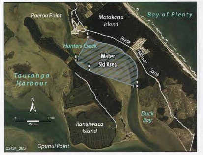
Hunters Creek is a sheltered part of the Tauranga Harbour located between Matakana Island and Rangiwāea Island. The sheltered nature of Hunters Creek makes the area one of the most sought-after locations in the harbour for boaties, passive recreational activities (e.g. swimming, kayaking, beach picnics) and active water sports.
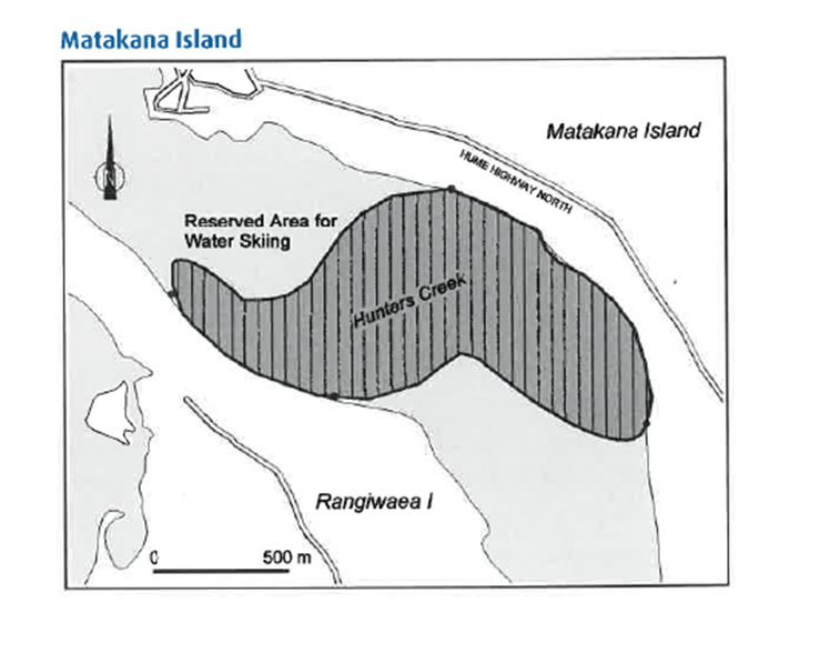
A significant part of the Hunters Creek is currently reserved as a water ski area. The water ski area extends to the shoreline of both Matakana Island to the north-east and Rangiwāea Island to the south-west. The ski area incorporates the main channel that meanders between the islands.
3.2 The Facts
The dynamics that play out in this small area of water are often in conflict with one another.
The facts, as they are at present, are:
· Hunters Creek has a dedicated Reserved Area under the Regional Navigation Safety Bylaws. For safety reasons, the Hunters Creek ski lane is closed to ski traffic for two hours either side of low tide. During this time the 5 knot rules apply to all vessels.
· Vessels must operate at a proper speed of 5 knots 200m from any shore, unless towing a person.
· No person can tow another between sunset and sunrise.
|
· Vessels includes vessel means every description of boat or craft used in navigation, whether or not it has any means of propulsion; and includes: (a) a barge, lighter (flat bottom barge), or other like craft (b) a hovercraft or other thing deriving full or partial support in the atmosphere from the reaction of air against the surface of the water over which it operates (c) a submarine or other submersible (d) a personal watercraft i.e. a jet ski (e) a seaplane when operating on the water |
· a sailboard, kiteboard, or paddleboard.
· The beaches of the island are considered common marine and coastal area under the Marina Coastal Area Act. This is the area between the line of mean high water springs (MHWS) (the landward boundary of the part of the beach covered by the ebb and flow of the tide) and the outer limits of the territorial sea (12 nautical miles).
· Western Bay of Plenty District Council is the territorial authority.
3.3 Bylaws History
2001 New Regional Bylaws made.
The Harbours Act (1950) (constituting Harbour Boards) was revoked in 2000. The Local government Amendment Act (No. 2) took its place outlining a new system of managing territorial waters. Existing Bylaws at the time expired in 2003. Regional Council worked with Maritime Safety Authority (since abolished) to develop a set of generic Bylaws for navigation and safety to bring greater uniformity across New Zealand (no hard copy available).
A Bay of Plenty Regional Council paper (Māori Standing Committee, 18 September 2001) outlined the development and consultation of a new Bay of Plenty Region Bylaws document under the generic bylaws. Environment Bay of Plenty Bylaws for Navigation and Safety were adopted by full Council, 16 August 2001.
 |
The original Bylaws document was reviewed in 2004 when updates were made to Maritime Rules Part 91: (Navigation Safety Rules) and Part 90 (pilotage). The review also undertook some minor changes.
Note: There were only general rules for skiing (clause 3.4 & 3.5). Map Schedule 3: Part B: Tauranga Harbour.
No submissions on Hunters Creek Ski Lane were received for this review.
2010 Review – Large number of submissions on Hunters Creek Ski Lane
Many submissions were received both in support of retaining the current ski lanes, and for removing some ski lanes, particularly at Hunters Creek (Matakana Island) and the eastern side of Motuhoa Island. The argument for retaining them was:
- they have been used for about forty years, are safe, sheltered, and able to be used at all tides and could not be replaced. The gently sloping beaches are good for families to picnic and for children learning to ski. Hunters Creek is well clear of navigation channels and main thoroughfares, and mostly surrounded by forestry blocks. The population of Tauranga City is increasing and more ski areas are required. There are no obvious alternative areas with similar attributes to Hunter’s Creek and Motuhoa Island. Removal of ski lanes would encourage unauthorised skiing off beaches elsewhere. Hunter’s Creek ski area is used for training for national wakeboarding, barefoot and slalom events.
Several submissions called for the establishment of more ski lanes including a new ski access lane at Fergusson Park and a new ski access lane at Dive Crescent. Requests were also received for extending the Hunters Creek ski area further south and re-instating the Wairoa River ski lane.
The argument for removal of the Hunters Creek and Motuhoa Island two ski lanes was summarised as:
- the increasing numbers of users have led to on-going problems for the residents on adjacent land. They submitted that their children can no longer safely swim on the beaches and the disturbance means that their customary rights, for example, food gathering, are severely restricted. Reported problems with people visiting the ski lanes include – rubbish being left behind, trespass on private land, theft of fuel, insanitary behaviour by boaties and families, and dogs allowed to roam on the islands.
Overall, submitters both for and against noted that the level of enforcement needed to be increased to ensure compliance with the rules and to maintain public safety and enjoyment for all.
The Bylaws were adopted retaining the Hunters Creek Ski Lane but voting was not unanimous. One of the Hearings Commissioners tabled a dissenting opinion at a subsequent Council Meeting – 15 July 2010.
 |
2011 Review of Water ski and other designated areas in Tauranga Harbour (not actual Bylaws review)
Opinion varied at the Council meeting on 15 July 2010 (Adoption of the Navigation Safety Bylaws 2010) as to whether the decision to retain the Hunters Creek Ski Lane satisfied all the needs of the community.
Council nevertheless adopted the Navigation Safety Bylaw 2010 with Hunter Creek included. It resolved to commence an urgent review of the location and operations of water ski areas in Tauranga Harbour, and amend the Bylaw if appropriate, through a motion:
That the Council request that the Regulations & Operations Committee commence with urgency a review of the particular circumstances around the location and operations of ski lanes in Tauranga Harbour.
A paper was brought to Operations, Monitoring and Reporting (OMR) committee (3 May 2011) on the Tauranga Harbour Navigation Safety Review.
The review focused on the location of water ski areas and the impacts these had on adjacent land and communities. It also provided an opportunity to look at other navigation issues concerning the community. Tensions between user groups highlighted the need for harbour users to know the rules and for Maritime officers to be seen to enforce them.
Extensive discussion took place, but no appropriate solution was found. A procedural motion meant the paper was “put to lie on the table” (i.e. no decision was made). A further report was to be brought back to Council in 6 months - this was not done however due to Rena grounding Oct 2011.
2015 Review
The 2015 Nav Safety Bylaws Review continued to see Hunters Creek Ski Lane as a dividing issue within the community, and a continued challenge for Council.
Again, there were a large number of submissions on Hunter Creek Ski Lane. Due to the ongoing controversial nature of this topic, Council sought Independent Commissioners to run the Hearings and Deliberations process for the review (Les Porter, Doreen Blyth, Gina Mohi).
The Independent Commissioners Review and Decisions Document outlined their rationale for their decisions and recommendations on the matter at the conclusion pf the formal process:
|
Whilst the issues concerning Hunters Creek are very real to the residents of Rangiwāea and Matakana Islands, there needs to be a more formal gathering of data. One group of users cannot be pinpointed as creating issues without evidence to support. The Commissioners can only make a decision based on the evidence put before them both in submissions and at the hearings. It was felt that the evidence provided was anecdotal and there was no substantiating evidence provided in support. The Commissioners were disappointed with the lack of evidence, and this has led them to make some strong recommendations to the BOPRC regarding the next Bylaw review. [excerpt from independent commissioners' report, point 1.20] |
|
Recommendations: |
|
1. A detailed data collection system is instigated by both the Harbourmaster and his team, and the Island Trustees with the view that at the next Bylaw Review date hard verifiable evidence will be available for consideration. [boat/jet ski speed and behaviour; increasing volume of ski lane users] |
|
2. That the Harbourmaster is able to increase patrols and maintain a more visible presence within the Hunters Creek area, particularly over the heavy summer season. |
|
3. That within the new edition of the “Boating in the Bay of Plenty” handbook that more detail and protocol are given regarding Hunters Creek and its community including the MHWS level and what that means for users. |
|
4. That signage is provided to signify private property above the MHWS level. |
|
5. That in the next review forestry haulage from Matakana Island will need to be taken into account. |
|
6. That a full assessment of ski areas within the Tauranga Harbour is undertaken, with data regarding usage and incidents recorded. |
|
7. Encourage serious relationship building at a Governance level with the Island Trustees. |
|
8. Swimming areas as noted by Island Trustees are identified and proposed accordingly in the next Bylaw review. |
All current (2017) clauses (emphasis added):
Speed of Vessel
|
3.2.1 |
No person shall propel or navigate a vessel (including a vessel towing a person or an object) at a proper speed exceeding 5 knots: (a) within 50 metres of any other vessel, raft, floating structure, or person in the water; or (b) within either 200 metres of the shore or of any structure, or on the inshore side of any row of buoys marking a 5 knot restriction; or (c) within 200 metres of any vessel or floating structure that is flying Flag A of the International Code of Signals (diver’s flag). |
|
3.2.2 |
No person shall propel or navigate a powered vessel at a proper speed exceeding 5 knots with any person at or on the fore part or bow of that vessel or with any portion of their body extending over the fore part, bow, or side of that vessel. |
|
3.2.3 |
No person in charge of a vessel shall permit the vessel to continue onwards, after any person being towed by that vessel has dropped (whether accidentally or otherwise) any water ski or any floating object which may cause danger to any other person or vessel, without first taking appropriate action to immediately recover that water ski or floating object, unless that person has taken measures adequate to ensure that the water ski or floating object is clearly visible to other water users. |
|
3.2.4 |
Clause 3.2.1(a) and (b) do not apply to: (a) a vessel over 500 gross registered tonnage, if the vessel cannot be safely navigated in compliance with clause 3.2.1(a) and (b); or (b) a vessel operating in an access lane or a reserved area for the purpose for which the access lane or reserved area was designated; or (c) a tug, pilot vessel, Harbourmaster vessel, emergency response craft or police vessel, if the vessel’s duties cannot be performed in compliance with clause 3.2.1(a) and (b); or (d) a craft training for or participating in competitive rowing or paddling; or (e) any rowing skiff, outrigger canoe or similar craft. |
Lookouts on Vessel used for Water Skiing or Towing a Person
|
3.4.1 |
No person in charge of a vessel may use it to tow any person unless at least one additional person is on board who is responsible for immediately notifying the person in charge of every mishap that occurs to the person who is being towed. |
|
3.4.2 |
No person may cause or allow himself or herself to be towed by or from any vessel unless at least one additional person is on board who is responsible for immediately notifying the person in charge of every mishap that occurs to the person who is being towed. |
|
3.4.3 |
No person who is under the age of 10 years is permitted to act as the additional person required by clauses 3.4.1 and 3.4.2. |
Water Skiing or Towing a person between Sunrise and Sunset
|
3.5.1 |
No person may operate, between sunset and sunrise or in restricted visibility, a vessel that is towing any person, whether or not the person being towed is on a water ski, aquaplane, barefoot, paraglider, or other similar object. |
|
3.5.2 |
No person may cause or allow himself or herself to be towed by a vessel between sunset and sunrise. |
|
3.5.3 |
For the purposes of this clause, the times of sunset and sunrise for any particular day are to be determined with reference to the current edition of the New Zealand Nautical Almanac. |
Designating Temporary or Permanent Access Lanes, Reserved areas and Speed Upliftings
|
3.6.1 |
The Council may designate an area of any navigable water as an access lane or reserved area for any specified purpose on a permanent or temporary basis. |
|
3.6.2 |
The Council may designate an area as being subject to a speed uplifting on a permanent or temporary basis. |
|
3.6.3 |
The areas Council has permanently designated as access lanes, reserved areas and areas subject to a speed uplifting are set out in Schedule 3. |
|
3.6.4 |
The area designated as the Hunters Creek Ski Area in Schedule 3 is a reserved area for skiing, except during the period being 2 hours before and after low tide when no person shall be towed and a 5 knot speed limit applies to all vessels within 200m of shore. |
|
3.6.5 |
For the purposes of Clause 3.6.4, low tide means that tide measured at Salisbury Wharf in Tauranga Harbour. |
Conduct in Access Lanes and Reserved Areas
|
3.7.1 |
No person shall, in any access lane, propel, navigate, or manoeuvre a vessel except by the most direct route along the access lane and on that side of the access lane that lies to the starboard (right-hand) side of the vessel. |
|
||
|
3.7.2 |
No person shall: (a) while being towed by a vessel in any access lane, cause himself or herself or any water ski, aquaplane or other towed object, on or by which he or she is being towed; or (b) cause any object that is being towed by a vessel in any access lane; to travel other than by the most direct route along the access lane and on that side of the access lane that lies to the starboard (right-hand) side of the vessel. |
|
||
|
3.7.3 |
Where there is more than one vessel towing within a reserved area for water skiing, all vessels shall navigate in an anti-clockwise direction. |
|
||
|
3.7.4 |
No person within an access lane or reserved area shall proceed in any manner that is dangerous in relation to any vessel or other person in the access lane. |
|
||
|
3.7.5 |
No person shall obstruct any other person while that other person is using an access lane or reserved area for the purpose for which it has been designated. |
|
||
|
3.7.6 |
Any vessel that is on the beach must be on the take-off (starboard) side of the access lane. |
||
|
3.7.7 |
No person may anchor a vessel in an access lane. |
||
Special Designated Areas
|
3.10.5 |
In a water ski area, no person shall operate a vessel at a proper speed greater than 5 knots unless towing into the area in an anticlockwise direction from shore. |
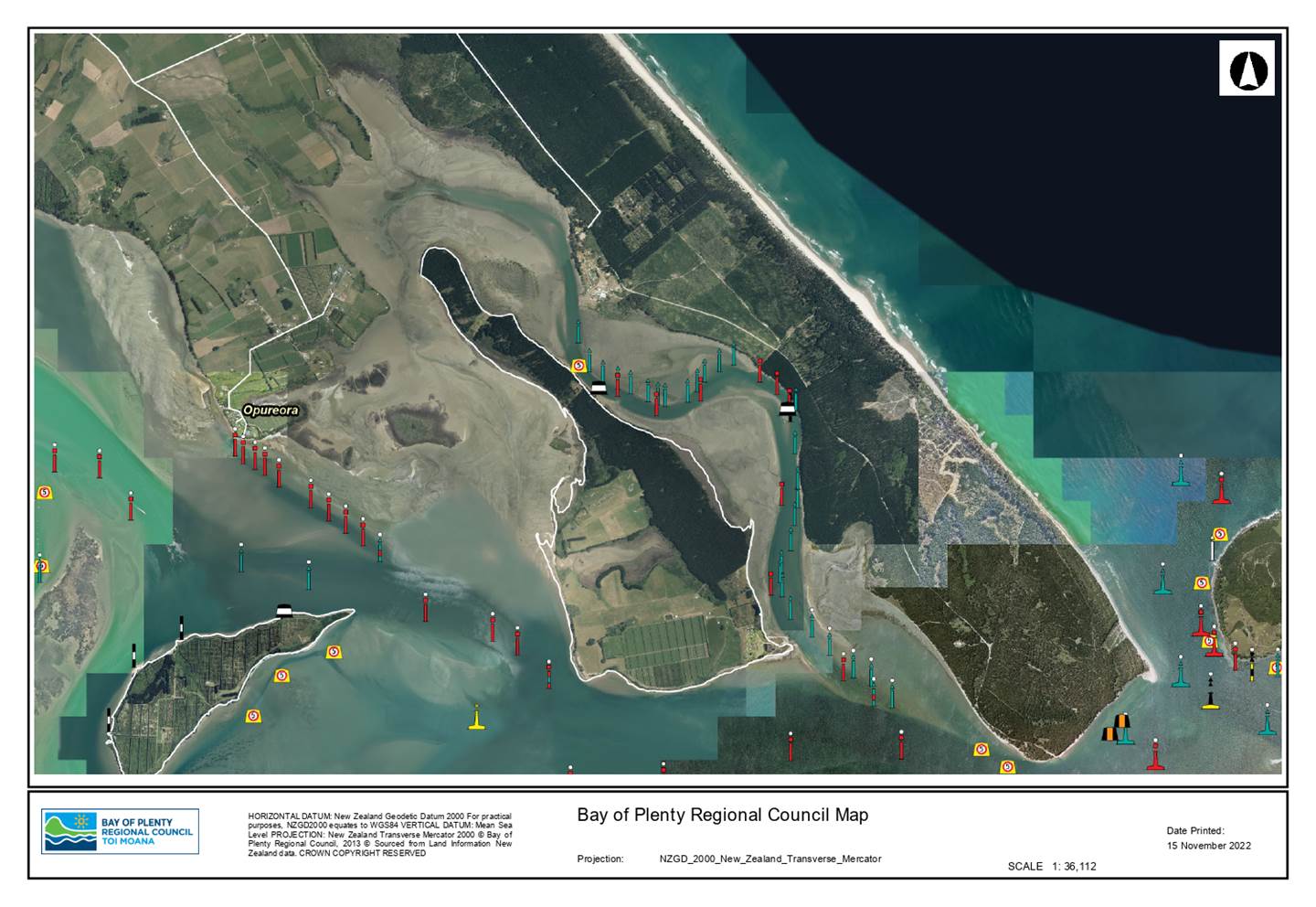
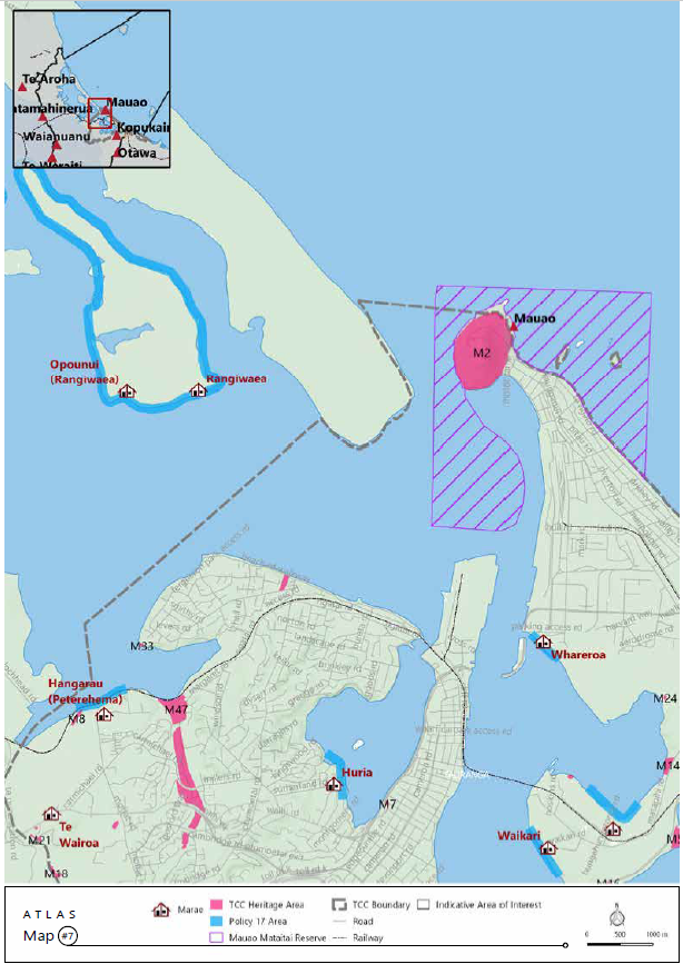
Hunters Creek Ski Area (see Attachment 1)
|
Schedule 3 |
In accordance with clause 3.6.4 and 3.6.5, the Hunters Creek Ski Area shall not be a reserved ski area during that period being 2 hours before and after low tide, measured at Salisbury Wharf in the Tauranga Harbour. |
3.4 Issues
A wide range of historical issues relating to Hunters Creek, its use and behaviour of some boaties in the area, have been consistently raised during reviews of the Navigation Safety Bylaws.
Some of the issues involve behaviour on the land, including littering, ablutions and entering Marae land. The land-based behaviour is out of the direct control of the Bylaws and Regional Council jurisdiction, although the Bylaws may be able to influence the behaviour indirectly by encouraging recreational boaties to utilise more appropriate parts of the harbour where there are onshore facilities.
As a result of the issues raised, a focussed review of the ski areas in the Tauranga Harbour was undertaken in 2011, following the adoption of the 2010 Bylaw Document (full document available). The objective of that review was to investigate the best arrangement of recreational space on the Tauranga Harbour and to confirm whether the relatively minor changes that were made as part of the Bylaw remained appropriate. The review did not result in any changes to the Bylaws however and the conflict between skiers, personal watercraft users and the Matakana Island and Rangiwāea Island communities, has remained.
Identified Issues (from previous feedback) are:
Issue 1: Observed behaviour seems to highlight that area users do not know the navigation safety rules.
Issue 2: Maritime officers cannot be in the area constantly to provide continuous monitoring and compliance
Issue 3: The ski lane is close to areas where residents swim
Issue 4: Occupants of vessels landing on the shore and leaving rubbish, lighting fires (despite island wide fire bans) and going to the toilet.
Issue 5: Otapu (Hunters Creek) is seen as the hapu’s Kapata Kai (food pantry). Gathering often conflicts with vessels speeding in the same area as swimmers and waders.
3.5 Other Considerations
3.5.1 Iwi Management Plans
2017 Matakana Island and Rangiwāea islands Hapū Management Plan (excerpts from HIP relating to Hunters Creek)
Environmental Threats and Challenges (pg. 17)
3. Threats from Poorly Constructed Policies and Planning Documents
Threats from poorly constructed policies of central government and local authorities have allowed permitted activities to negatively affect the Hapū of the Islands. The 2012 District Plan also proposes esplanade reserves around the whole of Matakana. This has serious ramifications for the hapū and our unencumbered access to our tribal estate.
These include policies for:
· Sewage pipeline discharge
· Reserves
· Horse trekking
· Boat and ski lanes
· Port of Tauranga dredging
· Shipping lanes
· Biosecurity
Perspectives (Appendix – Section3, pg. 22)
Boats and Ski Lanes
For over 30 years local government has maintained a ski lane policy for Matakana, Rangiwāea and Motuhoa Islands that we consider irresponsible and dangerous. Against our will, we are forced to endure jet skis and jet boats blasting through small tracts of water dangerously close to where we conduct everyday family activities. There have already been 2 water-related deaths.
We know of no comparable body of water in New Zealand where this would be considered legal, let alone safe. We object strongly to having our families’ safety, peace and wellbeing compromised by poorly constructed policies.
Ski Lanes
In 2015 the Hapu worked alongside Council staff to investigate the pros and cons for the continuation of the Hunters Creek (Otapu) ski lanes. Through discussions with key stakeholders, it was unanimously decided that the ski lane area was no longer safe and an alternative site was suggested. Whanau from near and far attended the process with strong evidence from the Hapu outlining the significance of the Hunters Creek (Otapu) area to the Hapu. It is an area that the Hapu aspire to set aside for ecological purposes – breeding grounds for the many fish and shellfish that inhabit Te Awanui harbour. Our main concern was around the Health and Safety issues which continue to pose significant risk to both public users and the Hapu(s). The Hapu also outlined the effects of how more and more people on boats, jetskis etc are leaving a bad mark on our Islands by using them as toilets, lighting fires, leaving bottles and rubbish littered along our coastline. Once again, our concerns as tangata whenua where being railroaded by political agendas despite our earlier positive discussions with Council staff who all supported our application. Our submissions were rejected with no explanation of the ruling explained to the Hapu. We still strongly oppose the location of the Hunters Creek ski lane and want it to be removed.
Issues Statements (pg. 36)
Issues Statement (14): Inappropriate placement of boat access and ski lanes and recreational boating activities generally
We strongly object to the inappropriate and dangerous placement of boat and jet-ski lanes, we want:
(i) Ski lanes situated dangerously close to the Islands closed
(ii) A robust infringement system for dangerous and reckless behaviour and tougher penalties for those who break the law
(iii) Better policing and enforcement
(iv) Hapu Enforcement Officers employed by Councils
(v) Clear signage for trespassing, fire dangers, disposal of rubbish, put up at wharves, ramps and other key areas determined by ngā Hapu
(vi) To establish MOUs with Maritime agencies, POT and all other stakeholders
(vii) Monitoring of environmental effects due to wave action
We want greater support -- particularly during summer months to police irresponsible behaviour by recreational boaters and visitors. Need clear signage, stronger by-laws, heavier penalties, and fines put in place. We also want the Councils to take the lead by setting better standards, protocols, policies, laws, and legislation for recreational boaters. We want our privacy respected.
Policies, Requirements and Desired Outcomes (pg. 40)
|
Protection of our Taonga |
|
||
|
Depletion of fish stocks from the harbour due to commercial, environmental degradation and recreational activities |
We want robust mechanisms that protect fish stocks into the future * The Hapu requires that the MOU between commercial fishers and our islands is given due consideration * We want limits set for sustainability * We have delegated Hapu kaitiaki with appropriate tikanga protocols *We want to fence off and plant all waterways that enter into the Tauranga harbour *We disapprove of ski lanes that impact breeding grounds within our marine ecosystems *We strongly oppose any commercial fishing of vessels greater than 3 tonnes fishing within 30 nautical miles from the Matakana coastline
|
|
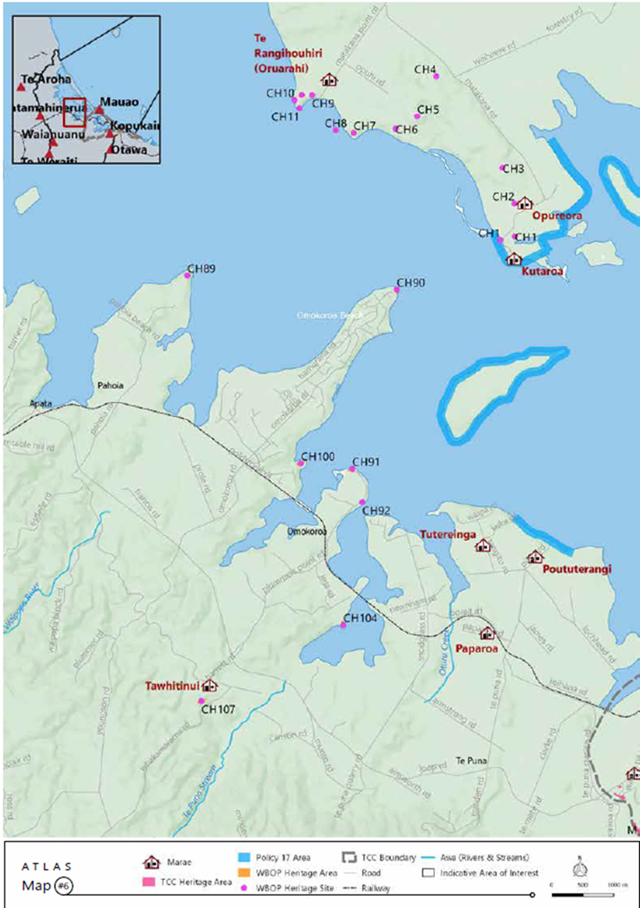
Tauranga Moana Iwi Management Plan 2016 - 2026
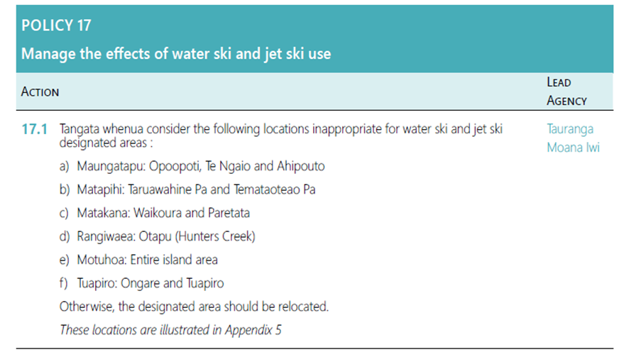
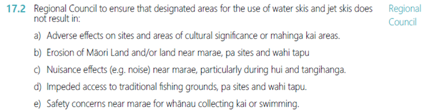
Appendix 5 Maps
3.6 2022/23 Current Engagement feedback so far
As part of our Phase 1 Engagement package, staff used the BOPRC engagement website Participate to gauge initial thinking with the community on a range of high level questions. One of those question focused on Hunters Creek ski lane.
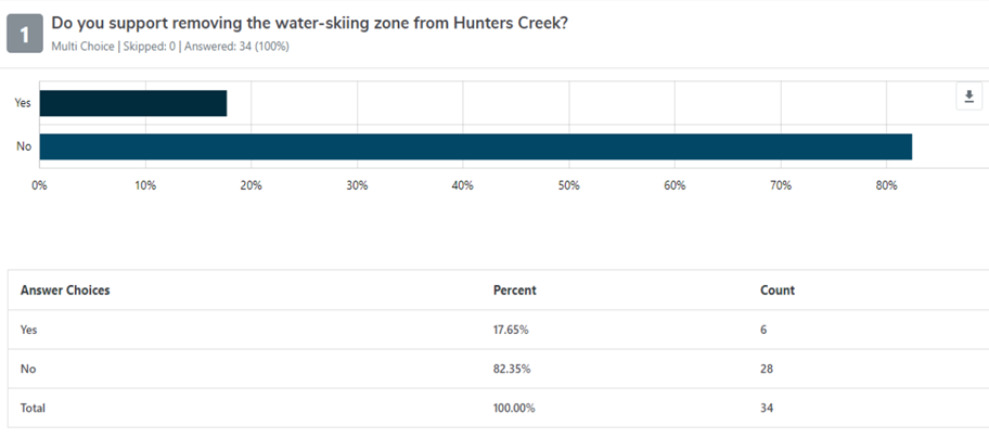
Staff do not see this as any sort of comprehensive indication of the whole cross section of the affected community but more of a directional touch point.
3.7 Options
Staff have put together the following table of possible options for discussion at this workshop to support discussion:
|
1. Option |
2. Synopsis |
|
3. 1: Status Quo (current situation) |
4. The area of Hunters Creek, between Matakana and Rangiwāea Islands is designated as a reserved area for skiing (only) between sunrise and sunset, two either side of low tide. |
|
5. 2: Status Quo with caveats |
6. Leave the Ski Lane where it is but add caveats around increased monitoring and compliance; undertaken partnerships with other entities to address non-bylaws issues (e.g. beach landings). |
|
7. 3: Move to Alternative Location |
8. Find an alternative location for a ski lane in Tauranga Harbour (there are presently three other ski areas in Tauranga Harbour). |
|
9. 4: Remove ski lane all together |
10. Remove the ski lane all together. Do not create another elsewhere |
The workshop will work through each option and discuss the pros, cons, risks, potential costs, and impacts.
An important consideration, as mentioned above, is that we have yet to discuss possible solutions with the affected communities, especially the Island hapū and trustees with long term concerns around the ski lane.
Today staff will explain the tentative options, provide the rationale and context for each and work through with the committee, possible best solutions.
4. Next Steps
The next step is to engage directly with the key stakeholders and tangata whenua on the options, especially the tangata whenua on Matakana Island and Rangiwāea Island. It will be most important to ask these stakeholders what they think a solution might be.
Staff are endeavouring to organise an engagement session with the Island Trustees and the Tauranga skiing clubs.
Attachment 1 - Hunters Creek ⇩